Interested in geophysical training for bedrock mapping?
With the growing concerns of well contamination due to farmland runoff, specifically manure, the Wisconsin Department of Natural Resources implemented legislation to help protect our water quality. It established NR 151, a piece of legislation that sets standards for the agricultural industry to follow. Before discussing training for bedrock mapping using geophysical methods, we must first review a couple key ideas.
What is NR151?
First, let’s yet again define NR 151. NR 151 is a chapter in the Wisconsin state legislature that deals with runoff management. Basically, it provides performance standards to protect the water quality of Wisconsin residents. Its purpose is as follows:
Purpose. This chapter establishes runoff pollution performance standards for non-agricultural facilities and transportation facilities and performance standards and prohibitions for agricultural facilities and practices designed to achieve water quality standards as required by s. 281.16 (2) and (3), Stats. This chapter also specifies a process for the development and dissemination of department technical standards to implement the non-agricultural performance standards as required by s. 281.16 (2) (b), Stats. If these performance standards and prohibitions do not achieve water quality standards, this chapter specifies how the department may develop targeted performance standards in conformance with s. NR 151.004.
This website, bedrockmapping.com, specifically deals with “NR 151.075 Silurian bedrock performance standards,” which sets compliance standards for agricultural facilities, both crop producers and livestock producers, that mechanically apply manure to cropland or pasture areas that are above Silurian bedrock.
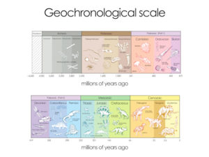
What is Silurian Bedrock?
In this context, Silurian bedrock is bedrock within 20 feet of the surface, comprising of a sedimentary rock called dolomite. Dolomite is a mineral forming rock similar to limestone in shape, color, hardness, and texture but has been chemically altered by the presence of magnesium. In Wisconsin, many times people think they are looking at limestone when they are technically looking at dolomite.
Silurian bedrock is the most prevalent bedrock in many counties of Wisconsin. In fact, the Silurian bedrock covers large portions of the following counties:
Brown Co., Calumet Co., Dodge Co., Door Co., Fond du Lac Co., Kenosha Co., Kewaunee Co., Manitowoc Co., Milwaukee Co., Outagamie Co., Ozaukee Co., Racine Co., Sheboygan Co., Walworth Co., Washington Co., Waukesha Co.
Why are areas of Silurian bedrock of concern?
Manure runoff often contaminates wells in regions of Silurian bedrock because the dolomite rock bed possesses weathered geology (i.e. fractures, faults, and karst features like disappearing streams, springs, fractures, and sinkholes.) Whereas a porous aquifer often filters groundwater before reaching the water table, the fractures and fissures in dolomite provides a direct conduit for contaminated wastewater to reach a well.
In regions with very shallow bedrock such as Kewaunee and Door counties, the manure runoff is becoming a problem that cannot be ignored. In 2017, in Kewaunee, where cows outnumber people 5 to 1, up to 60% of private wells tested positive for fecal microbes such as cryptosporidium. (https://www.postcrescent.com/story/news/investigations/2017/06/08/fecal-microbes-found-60-percent-sampled-kewaunee-county-wells/382399001/). Likewise, in Door County, up to 20% possessed fecal microbes. And while a water well can test negative for bacteria one day, it can be positive the next day because the rate at which the groundwater reaches the water table is very quick with karst geology due to providing a direct connection from ground water to the water table. (https://www.greenbaypressgazette.com/story/news/local/door-co/2016/06/10/door-county-wells-impacted-karst-geology/85677580/).

What are the standards for manure management in areas of Silurian bedrock?
Administrative code NR151.075 provides specific rules for mechanically spreading manure depending on the depth of Silurian bedrock. To read the exact legislation, please visit https://docs.legis.wisconsin.gov/code/admin_code/nr/100/151/II/015/17
One main point of emphasis is that all crop producers and livestock producers that mechanically spread manure are forbidden from causing fecal contamination of a well and must comply to a nutrient management plan that is consistent with NR 151.07 and NRCS Technical Standard 590, dated December 2015. This nutrient management plan must use soil surveys/information or other methods as a planning tool to identify bedrock within or adjacent to cropland or pastures.
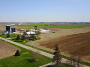
The biggest problem with bedrock maps is that they are neither accurate enough nor do they possess enough detail to truly map specific farmland. For this reason, we are willing to provide geophysical training for bedrock mapping to professionals who want to use geophysical equipment to map bedrock in farm fields. This assistance can help farmers and agricultural facilities to become compliant with NR 151.
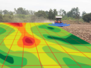
What instruments or methods can we use to map bedrock?
A variety of geophysical instruments posses the ability to map bedrock. Each method and piece of equipment serves a different purpose and there is no one instrument that will work in all instances. Therefore, it may be a good idea to refer to bedrock maps to get an idea of bedrock depths and visit the survey site to perform a preliminary inspection. It is not always an easy task to determine the best method or piece of equipment to use.
Methods and Instruments:
As one will find out over time, many instruments may overlap in their ability to map bedrock. While people with little geophysical training or expertise often fall back on what they are familiar with, geophysical training may open doors to new geophysical approaches that are better for a specific site.
Electromagnetics:
Electromagnetics is a geophysical method that uses the interaction between a magnetic field and the soil’s conductivity. Essentially, an electromagnetic instrument uses a transmitter that induces eddy currents, which create a magnetic field. This primary magnetic field interacts with the terrain’s conductivity, which creates a secondary magnetic field. The instrument’s receiver then intercepts the secondary magnetic field that outputs voltage. With equipment like Geonics EM38, EM31, and EM34’s the voltage is linearly related to the terrain conductivity in suitable soils. Mapping bedrock and soils becomes possible because different soil types have different terrain conductivities.
It is important to know the approximate depth to bedrock when using electromagnetic instruments because their maximum depth of penetration is dependent on the spacing between the transmitter and receiver. For instance, a Geonics EM38 has a small coil spacing of 1 meter (3.28 ft) and therefore can only reach depths of approximately 5ft, which would not map bedrocks down at 10ft. Hence, it is important to know the approximate depth of bedrock when looking for it with electromagnetic equipment.
Typical electromagnetic instruments used to map bedrock:
Geonics EM38, EM31 Short, EM31, and EM34. From a training point of view, these are some of the most user friendly instruments. Since they are not primary for determining accurate depths, interpretations are made using plan view maps, when one collects larger data sets. Mapping variations across a site using a Geonics terrain conductivity meter (also see OhmMapper) is likely a starting point for any bedrock mapping program.
Resistivity Imaging or Tomography:
Resistivity imaging is a geophysical method that simply measures the electrical resistance of the ground below it to determine different soil and rock types. Basically, most resistivity imaging is done by inserting metal electrodes into the ground. These electrodes put current into the ground and then other electrodes measure the resistance between the two points. Depending on the electrode spacing, apparent resistances will be measured at different depths. Using 56 or 84 electrodes with an eight channel systems allows a great amount of data at various depths to be collected.
Finally, with that said, it can be tedious to collect from multiple locations. Once this equipment is programmed, which takes experience, it is fairly simple to operate. Given that it takes one to three hours to collect most data sets, one may consider collecting other types of data while waiting for the instrument to finish. Processing and interpretation requires experience and working knowledge of how electricity responds to the earth.
Typical resistivity equipment used to map bedrock:
Advance Geoscience Inc. or AGI’s SuperSting R8. This is the brains or the main console. To complete the system one needs a set of cables, a switch box, and electrodes.
Resistivity Imaging and Profiling with Geometrics Ohmmapper:
The geometrics ohmmapper is a capacitively coupled resistivity meter that measures the electrical resistivity properties of different soils without metal electrodes placed in the ground. Instead it uses a transmitter and receiver sections that a user pulls along the ground. The depth of investigation depends on the distance between the transmitter dipole and the receiver dipole. Its major advantage over traditional resistivity imaging is that it can be pulled over the ground. Therefore, a large amount of area can be covered in a shorter amounts of time, much like electromagnetic instruments. Depending on how the OhmMapper is set up, this system is capable of creating large scale plan view maps like an EM38 or EM31, as well as cross-sections of electrical resistance as function of depth.
Seismic Imaging:
Seismic imaging is a geophysical method that involves putting energy into the ground (usually a sledge hammer and plate) and measuring the movement of the energy. Geophones turn ground movement into voltage that can be measured by a seismograph. A seismograph is connected to an array of geophones, usually 24 to 48 channels, at various intervals to reach different depths of investigation. For bedrock surveys less than fifty feet a sledge hammer is commonly used as the source of energy. Different soil types and rock respond differently to the energy put into the ground.
Both MASW, initialism for multichannel analysis of surface waves, and refraction surveys can determine depth to bedrock. Post processing software provides 1D and 2D models for bedrock. Like the resistivity imaging, seismic imaging explores many depths along a line. However, it can be tedious to collect a large amount of data in multiple locations. This method, like electrical resistivity tomography, takes more time to cover spatially large areas. For one to conduct a MASW or refraction survey, one needs to understand how to operate a Geometrics Geode or other seismograph. More or less, one can learn to operate and record data within hours. Though it takes a deeper understanding of the physics involved to configure the equipment for its application. Above all, survey design, processing, and interpretation is best left to those with experience.
Typical seismic imaging equipment used to map bedrock:
As a minimum, one needs a Geometrics geode (24 channel), geophones, cables, sledge hammer, and hammer plate. Depending on the survey design one may decide to use a land streamer (a set of cables and geophones that is towable) or larger arrays using multiple cables and a roll box.
Ground Penetrating Radar:
Ground penetrating radar, commonly called GPR, is a geophysical method that uses a transmitter to send radio pulses through the soil. When the radio pulse encounters buried objects, groundwater, or boundaries between soil and/or rock types due to different permittivity, some of the radio pulse reflects back to the equipment’s receiver. Different frequency antennas, measured in megahertz or MHz, are able to reach different depths. The lower the frequency of the antenna, the deeper the equipment will reach. However, lower frequencies will provide less detail. Generally, good antennas for mapping bedrock to depths less than 25 feet have a center frequency less than 250 MHz.
GPR can then measure the depth to an object or boundary, if one can estimate the speed of pulse. Depending on the material, the pulse travels at various speeds (e.g., damp soils are about 0.328 feet per second and dry rock about 0.45 feet per second). While GPR can be an asset to bedrock mapping, it has difficult time penetrating deep soils. Today, this is not as big of a problem as it was before 2019. Sensors & Software introduced the Ultra receiver that is capable of imaging depths twice as deep as older systems. After one configures a GPR system for the desired site conditions, the instrument is easy to operate. In areas with good soil conditions, interpretation is straight forward. However, groundwater, changing soils, and depth to rock greater than 10 to 15 feet may be best left to those with more experience.
Typical GPR instruments used to map bedrock:
Sensors & Software PulseEKKO Pro with 200, 100, or 50 MHz antennas.
For very shallow bedrock Sensors & Software Noggin Smartcart with 250 MHz antenna.
Global Positioning System:
GPS works in conjunction with a number of different instruments above. GPS accuracy can vary greatly. Most survey grade GPS unit’s measure from sub-meter to sub-centimeter. More accurate GPS units often are more expensive and may require a GPS service subscription or RTK technology. In addition, most bedrock mapping surveys will not demand the most accurate of GPS units. Ultimately, GPS should never replace good field practices and field notes.
Typical GPS equipment:
Hemisphere A100, A101, or A222.
Hemisphere Atlaslink.

Who provides professionals geophysical training for bedrock mapping on cropland or pasture land?
Art Fromm, president of KD Jones Instrument Corp and Geophysical Services LLC, is willing to assist with geophysical training for agronomists, geologists, engineers, and other related professionals on how to use the instruments mentioned above for mapping bedrock. I must point out this level of geophysical training is intended to help one get started with basic operation of an instrument(s) and is not a substitute for experience. Basic geophysical training for bedrock mapping will include discussions on:
Geophysics Overview:
What geophysical methods possess the ability to map bedrock?
What are the positive and negative aspects of each method?
How does one determine which method of geophysics to use for mapping bedrock?
Fieldwork Overview:
General guidelines to fieldwork.
Field day using some of equipment. (Tailored to your class.)
Please call 262-442-6745 or art@kdjonesinstruments.com to inquire about individual or group training for bedrock mapping.
Why are we willing to provide geophysical training for bedrock mapping for NR 151 compliance?
Geophysical Services LLC has been performing geophysical services since 1985. We want to help professionals perform bedrock mapping surveys for NR 151 compliance with infield bedrock verification because we recognize that without infield bedrock verification manure management over Silurian bedrock is potentially a public health hazard. With that said, Geophysical Services LLC is willing to assist with your geophysical training on how to map bedrock. Furthermore, our sister company, KD Jones Instrument Corp, can rent or sell you the equipment needed to perform such bedrock mapping surveys.

Glossary of Definitions and Terms for Mapping Bedrock
How much land is needed for a livestock nutrient management program?

What areas benefit the most from an infield bedrock verification survey?

Summary of the HYDROGEOLOGICAL CHARACTERIZATION OF THE TOWN OF LINCOLN, KEWAUNEE COUNTY, WISCONSIN
What is top of bedrock?

Geology, Groundwater, Geophysics, and WI DNR NR 151 Runoff Management Standards

A History of Groundwater Protection Past Present and Future

References and links for agricultural professionals, farmers, engineers, geologists, geophysicists,…