KD Jones Instrument Corp in conjunction with BedrockMapping.com offers geophysical equipment rental and sales for mapping bedrock. Please understand that actual weights, dimensions, and specifications may change without notice. KD Jones Instruments represents the following companies, which may help you map bedrock:
Geonics Instruments geophysical equipment rental and sales:
Geonics has been a leader in electromagnetic equipment since its formation in the 1960s. Their equipment possesses a reputation of cost effective equipment and reliability in the field. In addition to time domain and UXO metal detection, it produces ground conductivity meters. Since different layers of soils have different electromagnetic properties, its ground conductivity meters are most useful to determine the depth of surface to bedrock. These meters’ ability to reach a certain depth is dependent upon the space between its transmitter and receiver also known as the intercoil spacing. In general, in the vertical dipole mode, a ground conductivity meter will reach 1.5 times its intercoil spacing whereas in the horizontal dipole mode a ground conductivity meter will reflect conditions to 0.75 times its intercoil spacing.
Geonics instruments used to map bedrock that K. D. Jones Instruments rents:
EM38/EM31/EM31 Short:
All three of these Geonics meters function and perform the same. They are handheld conductivity meters in which the operator walks along survey lines collecting data at different stations with a data logger. The difference between the three meters is the spacing of the transmitter and receiver, meaning they will reach different depths. For this reason, it may be important to look at bedrock depth maps to have a general idea of what meter one will need. Some users like to use GPS with the Geonics equipment while others prefer a making a grid.
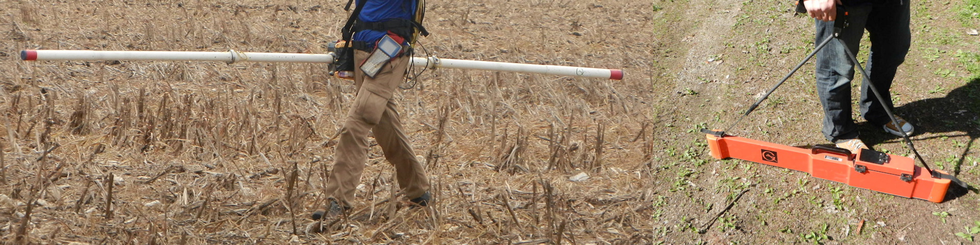
Geonics EM31 on the left and an EM38 on the right.
EM31 and EM31 Short Specifications:
| EM31 Specifications | |
| Maximum Depth of Investigation | EM31 Short: to a depth of about 13 feet, depending on instrument height and conductivity.
EM31: to a depth of about 18 feet, depending on instrument height and conductivity. |
| Rental Prices | $85 a day or $2,040 a month, $100 prep fee |
| Estimated Shipping Dimensions | 60 x 9 x 14 inches |
| Estimated Shipping Weight | 60 lbs |
| Power Source | 8 “C” Cell Batteries |
| Other notes: | |
| Measured Quantities: 1: Apparent conductivity in millisiemens per meter (mS/m) 2: In-phase ratio of the secondary to primary magnetic field in parts per thousand (ppt) |
|
| Intercoil Spacing:
EM31 Short: 6.56 feet (2 meters) |
|
| Operating Frequency: 9.8 kHz | |
| Measuring Ranges: EM31 Short: Conductivity: 19, 199, 1999 mS.m; Inphase: +/- 6ppt
EM31: Conductivity: 10,100,1K mS/m; Inphase: +/- 20 ppt |
|
| Measurement Resolution: +/- 0.1% of full scale | |
| Measurement Accuracy: +/- 5% at 20 mS/m | |
| Noise Levels: Conductivity: 0.1 mS/m. In-phase: 0.03 ppt | |
| Ability to use in conjunction with GPS antenna |
EM38 Specifications:
| EM38 Specifications | |
| Maximum Depth of Investigation | Depths depend on instrument height and conductivity. For coil spaces of 1 m less than 5 feet and for 0.5 m less than 2.5 feet. |
| Rental Prices | $85 a day or $2,040 a month, $100 prep fee |
| Estimated Shipping Dimensions | 45 x 12 x 11 inches |
| Estimated Shipping Weight | 45 lbs |
| Power Source | One 9v battery or a battery belt pack |
| Other notes: | |
| Measured Quantities:
1: Apparent conductivity in millisiemens per meter (mS/m) 2: In-phase ratio of the secondary to primary magnetic field in parts per thousand (ppt) |
|
| Intercoil Spacing: 3.28′ and 1.61′ (1 and 0.5 meters) | |
| Measuring Ranges: Conductivity: 1000 mS/m In-phase: ± 29 ppt for 1 m In-phase: ± 7 ppt for 0.5 m |
|
| Measurement Resolution: +/- 0.1% of full scale | |
| Measurement Accuracy: +/- 5% at 30 mS/m | |
| Noise Level: Conductivity: 0.5 mS/m; In-phase: 0.02 ppt |
|
| Ability to use in conjunction with GPS antenna |
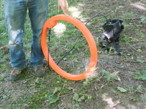
Geonics EM34 Transmitter Coil.
EM34:
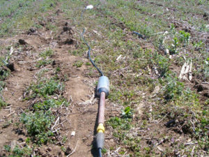
The EM34 operates similarly to the other meters but it is not handheld. Instead, it possesses a receiver and transmitter coil separated by a long cable. This cable comes in lengths of 10, 20, and 40 meters, allowing it to reach much greater depths than the other instruments. However, with the ability to reach greater depths comes a lack of mobility and potentially less value for bedrock mapping surveys of depths less than 25 feet.
EM34 Specifications:
| EM34 Specifications: | |
| Maximum Depth of Investigation: | Since the coils are set on the ground, depths depend more on conductivity. Approximate depth
for a coil space of 10 m is less 49 feet, 20 m less than 98ft, and for 40 m less than 196 feet. |
| Rental Prices | $85 a day or $2,040 a month, $100 prep fee (no data logger) |
| Estimated Shipping Dimensions | 32 x 32 x 14 inches |
| Estimated Shipping Weight | 105 lbs |
| Power Source | Tx: 8 D batteries Rx: 8 C batteries |
| Other notes: | |
| Measured Quantities: Apparent conductivity in millisiemens per meter (mS/m) | |
| Primary Field Source: Self-contained dipole transmitter | |
| Intercoil Spacing and Operating Frequency: 10 m at 6.4 kHz (32.8 feet) 20 m at 1.6 kHz (65.6 feet) 40 m at 0.4 kHz (131.23 feet) |
|
| Measuring Ranges: Conductivity: 10, 100, 1k mS/m | |
| Measurement Resolution: +/- 0.1% of full scale | |
| Measurement Accuracy: +/- 5% at 20 mS/m | |
| Noise Levels: Conductivity: 0.2 mS/m (can be greater in regions of high power line interference) |
Advanced Geoscience, Inc geophysical equipment rental and sales:
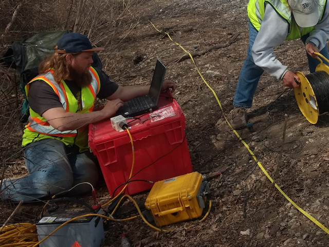
Advanced Geoscience Inc., commonly referred to as AGI, is a leading developer of resistivity imaging. Since 1989, they have been developing their own resistivity imaging hardware and post processing software. Furthermore, their equipment has been involved in more than 1,000 peer reviewed journal articles. Resistivity imaging meters require a user to set electrodes into the ground. Pairs of electrodes are used to inject current into the ground and to measure the resulting voltage between other pairs of electrodes. The apparent resistance is then measured between pairs of electrodes, which will differentiate bedrock from other soils. Since our system uses an array up to 84 electrodes the AGI Supersting system provides an incredible amount of data. Different depths are achieved depending on the distance between electrodes and the number of electrodes.
Advanced Geoscience, Inc instruments used to map bedrock that K. D. Jones Instruments rents:
SuperSting R8 84 and peripherals
The SuperSting is powerful electrical resistivity meter and induced polarization (IP) and self-potential (SP) system that creates 2D slices and 3D volumes to create an image of the subsurface. Its multichannel capability has been proven in over 700 peer-reviewed journal articles, and it delivers the highest accuracy and lowest noises levels in the industry. Electrode arrays of 56, 84, or 112 takeouts can be rolled to provide a vast amount of data along a line.
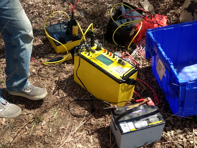
AGI SuperSting R8 resistivity imaging console and switch box. Geonics EM31 on the left and an EM38 on the right from K. D. Jones Instruments geophysical equipment rental.
SuperSting R8 84 Channel System Specifications:
| Supersting R8 System Specifications | |
| Maximum Depth of Investigation | ??? |
| Prep Fee | $380 |
| Rental Prices | $430 a day or $10,320 a month |
| Estimated Shipping Dimensions | SuperSting R8: 24 x 20 x 16 inches Switch Box: 20 x 16 x 8 inches (2) Cables 28 x 21 x 18 inches Electrodes: 22 x 15 x 10 inches |
| Estimated Shipping Weight | SuperSting R8: 50 lbs Switch Box: 22 lbs (2) Cables 70lbs Electrodes: 60lbs |
| Power Source | External 12v marine or car battery (not included) |
| Other notes: | |
| Measured Quantities: Apparent resistivity, resistance, induced polarization (IP) | |
| Measuring Ranges: +/- 10V | |
| Measurement Resolution: Max 30 nV, depends on voltage level | |
| Output Current: 1 – 2,000 mA continuous, measured to high accuracy | |
| Output Voltage: 800 Vp-p, actual electrode voltage depends on transmitted current & ground resistivity. | |
| Input Channels: 8 channel | |
| Total Accuracy: Better than 1% of reading in most cases (lab measurements). Field measurement accuracy depends on ground noise & resistivity. The instrument will calculate & display running estimate of measuring accuracy. |
Geometrics geophysical equipment rental and sales:
Since 1969, Geometrics has produced seismographs, magnetometers, and geoelectrical instruments to survey the earth’s subsurface. Geometrics Geode seismograph is an industry workhorse, frequently equipped with 24 channels. Both multichannel analysis of surface waves (MASW) and refraction are common methods used with the Geode to map bedrock. Along with a Geode, customers rent cables and geophones. Geophones are the sensors which pick up seismic energy and the cables connect the geophones to the seismograph. Sometimes the geophones and cable are configured on a tow strap with fixed plates. This towable array is called a land streamer.
Geometrics also makes the only capacivitely-coupled resistivity meter called the Ohmmapper. This instrument can take soil resistivity measurements while being dragged or towed, which makes it much faster than systems that need electrodes put into the ground. In addition, it can be used with a GPS to precisely track where readings occurred.
Geometrics instruments used to map bedrock that K. D. Jones Instruments rents:
Geode
The Geometrics Geode is a small portable seismograph that can perform surveys up to 24 channels. Units are combined for longer arrays. Multiple geodes can be tethered together to create surveys up to 1000 channels or a rollbox can be used to perform larger surveys. It will run all day on a 12v battery and sleeps when not in use. Its interface connects to a laptop computer and parameters are changed in its acquisition software, Seismodule Controller.
Geometrics Geode Seismograph and Geophones from K. D. Jones Instruments geophysical equipment rental.
Geode Specifications:
| Geode Specifications | |
| Maximum Depth of Investigation | Often less than 500 ft for shallow near surface geophysical applications. |
| Prep Fee | $110 |
| Rental Prices | $1a day or $2,640 a month |
| Additional Peripherals Needed | Geophones and Spread Cables (prices below) |
| Estimated Shipping Dimensions | Geode Box: 28 x 22 x 18 inches
Geophone Box: 28 x 22 x 18 inches Land Streamer Box: 28 x 22 x 18 inches |
| Estimated Shipping Weight | Geode Box: 65 lbs
Geophone Box: 60 lbs Landstreamer Box: 115 lbs |
| Other notes: | |
| Measured Quantities: MASW, Refraction, or Reflection seismic data | |
| DynamicRange: 144 dB (system), 110 dB (instantaneous, measured) at 2ms, 24dB. | |
| Distortion: 0.0005% @ 2 ms, 1.75 to 208 Hz. | |
| Bandwidth: 1.75 Hz to 20 kHz. Low corner frequency option available. | |
| Common Mode Rejection: > -100 dB at <=100 Hz, 36 dB. | |
| Crosstalk: -125 dB at 23.5 Hz, 24 dB, 2 ms. | |
| Noise Floor: 0.2uV, RFI at 2 ms, 36 dB, 1.75 to 208 Hz. | |
| Stacking Trigger Accuracy: 1/32 of sample interval. | |
| Maximum Input Signal: 2.8 VPP. | |
| Input Impedance: 20 kOhm, 0.02 uf |
| Geode Peripherals | |
| Geophones | |
| Geophones 14 Hz vertical (24 channels) | Prep: $40 Daily: $20 Monthly: $480 |
| Geophones 8 Hz horizontal (24 channels) | Prep: $40 Daily: $20 Monthly: $480 |
| Geophones 4.5 Hz vertical (124 channels) | Prep: $40 Daily: $25 Monthly: $600 |
| Spread Cables | |
| 10ft Spread Cables (24 channels) | Prep: $40 Daily: $15 Monthly: $360 |
| 20ft Spread Cables (24 channels) | Prep: $40 Daily: $15 Monthly: $368 |
| Land Streamer Cable (24 channels) | Prep: $120 Daily: $80 Monthly: $1,920 |
Ohmmapper
The Ohmmapper is a capacivitely-coupled resistivity meter that can collect data at a blazing rate compared to a traditional resistivity meter with stakes in the ground. Further, its less susceptible to noise, which means it operates in areas that other meters cannot. Finally, it can be used over a variety of terrains such as concrete, asphalt, ice, or other hard surfaces whereas the traditional meter requires the user to drill holes to insert electrode spikes into the ground.
Geometrics OhmMapper Towed Array.
Geometrics Ohmmapper Specifications:
| Ohmmapper Specifications | |
| Maximum Depth of Investigation | Often less than 50 to 100 ft depending on soil resistivity. |
| Prep Fee | $175 |
| Rental Prices | $175 a day or $4,200 a month |
| Estimated Shipping Dimensions | Box 1) 28 x 22 x 18 inches Box 2) 34 x 17 x 15 inches |
| Estimated Shipping Weight | Box 1) 60 lbs Box 2) 80 lbs |
| Power Source | 24v battery for console. Eight 6v batteries for TX and RX. |
| Other notes: | |
| Measured Quantities: Constant-current capacitively-coupled, dipole-dipole resistivity | |
| Operating range: Less than 1 OhmMeters to greater than 100,000 OhmMeters | |
| Cycle Rate: Signal sample and data logging rate at 2 times per second | |
| Survey Types: 1. Continuous, constant-offset dipole-dipole resistivity. (Multi-line with constant transmitter-receiver spacing for plan-view mapping.) 2. Variable-offset, dipole-dipole resistivity. (Variable transmitter-receiver spacing for multiple passes on a single profile line to create a pseudosection.) |
|
| Ability to use in conjunction with GPS antenna |
Sensors & Software geophysical equipment rental and sales:
Sensors and Software is a leader in the field of ground penetrating radar. In fact, their founder, Peter Annan, helped pioneer both ground penetrating radar and airborne electromagnetic technologies, making the company experts in their field. In the simplest terms, ground penetrating radar sends radio pulses into the ground that reflect or distort when they encounter materials or objects of different properties. The time it takes for a pulse to reach an object, bounce off it, and come back to instrument reflects how deep a target is if the speed of the pulse is a known. Ground penetrating radar systems are often used to image the subsurface surfaces such as soil, rock, groundwater, pavement, concrete, utilities, and ice.
Sensors & Software GPR units used to map bedrock that K. D. Jones Instruments rents:
Noggin Smartcart with 250 MHz antenna:
The Noggin Smartcart is a four-wheeled, foldable GPR cart system that can use a multitude of different antenna frequencies. The foldable cart assembles in less than a minute. In addition, the survey menus that configure grid or line surveys are very user friendly. For shallow bedrock mapping, we offer the Noggin 250 MHz antenna. In favorable conditions, this antenna frequency can reach depths of 10 to 15 feet.
Noggin 250 Specifications:
| Noggin 250 Specifications: | |
| Maximum Depth of Investigation | 20 feet |
| Prep Fee | $175 |
| Rental Prices | $165 a day or $3,960 a month |
| Estimated Shipping Dimensions | 46 x 24 x 19 inches |
| Estimated Shipping Weight | 100lbs |
| Power Source | 12v in Pelican Case |
| Other notes: | |
| Center Frequency: 250 MHz | |
| Shielding Front to Back | |
| Acquisition Rate*: 100,000 samples/second | |
| Stacks (N):Unlimited, DynaQ® when odometer triggering | |
| Ability to use in conjunction with GPS antenna |
PulseEKKO Pro Smartcart with 50, 100, or 200 MHZ antennas:
The PulseEKKO Pro Smartcart is a four wheeled, foldable GPR cart system. It takes a bit more time to physically set up than the Noggin system due to its bistatic antennas, but it is more versatile in application and its frequency selection. For bedrock mapping, we suggest the 50, 100, and 200 MHZ antennas, which can reach depths of 65 ft, 32 ft, and 16 ft in ideal soil conditions. With the introduction of the newly developed Ultra receiver (January 2019), one can reach depths of less than 25 ft with great certainty.
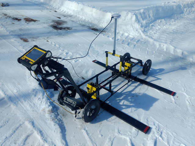
Sensors & Software pulseEKKO GPR with Ultra Receiver from K. D. Jones Instruments geophysical equipment rental.
PulseEKKO Pro Specifications:
| PulseEKKO Pro Specifications: | |
| Maximum Depth of Investigation | 50MHz: 65 feet
100MHz: 33 feet 200MHz: 16 feet |
| Prep Fee | $265 |
| Rental Prices | $300 a day or $5,450 a month (standard receiver)
$380 a day or $6,900 a month (ultra receiver) |
| Estimated Shipping Dimensions | Cart Box: 59 x 21 x 13 inches
DVL Box 25 x 25 x 19 inches |
| Estimated Shipping Weight | 100 lbs and 80 lbs |
| Power Source | 12v in pelican case |
| Other notes: | |
| Center Frequency: 50, 100, or 200 MHz | |
| Bistatic, unshielded antennas | |
| Acquisition Rate*: 100,000 samples/second | |
| Stacks (N):Unlimited, DynaQ® when odometer triggering | |
| Ability to use in conjunction with GPS antenna |
Hemisphere geophysical equipment rental and sales:
Hemisphere produces quality global positioning systems used in geophysical, agricultural, GIS, survey, marine, construction, and other industries. These GPS units are easy to use with bedrock mapping instruments. Users need to connect the GPS to an instrument (or data logger) via data cable, then connect the power to the GPS unit, wait for the GPS to lock-in a signal, and begin logging data. GPS made by Hemisphere units are commonly used with GPR, electromagnetic, and capacivitely-coupled resistivity meters.
Hemisphere instruments used with equipment that maps bedrock that K. D. Jones Instruments rents:
A100, A101, and A222 GPS receivers
Hemisphere A100, A101, and A222 GPS single-frequency receivers are rugged and easy to use. They mount to a GPS staff via 5/8” threaded bolt and connect to most instruments via a 9 pin serial adapter. After connecting to power, they acquire fixed quality data in 5-10 minutes, which can be seen as the GPS’s indicator light changes from red (no signal) to orange (signal, float quality) to green (signal, fixed signal.) The unit uses little power, and batteries typically last all day. Accuracy is submeter.
Specifications:
| Hemisphere Specifications | |
| Prep Fee | $35 |
| Rental Prices | A100 or A101: $35 a day or $840 a month. |
| Estimated Shipping Dimensions | 22 x 15 x 12 inches |
| Estimated Shipping Weight | 22 lbs |
| Power Source | 12v battery |
| Other notes: | |
| Connects via RS232 serial port | |
| Positional Accuracy: 60cm 95% of time Atlaslink Positional Accuracy: 30 to 50cm 95% of time |
AtlasLink
The Hemisphere Atlaslink multi-frequency receiver is also rugged and easy to use. Like other Hemisphere antennas, it mounts to a 5/8” threaded bolt, transfers data via 9 pin serial, and uses little power. Unlike other receivers, it receives corrections from Atlas GNSS global correction service, meaning it retains 30-50cm accuracy 95% of the time.
Specifications:
| AtlasLink Specifications | |
| Prep Fee | $35 |
| Rental Prices | Atlaslink: $58 or $1,392 a month |
| Estimated Shipping Dimensions | 22 x 15 x 12 inches |
| Estimated Shipping Weight | 22 lbs |
| Power Source | 12v battery |
| Other notes: | |
| Connects via RS232 serial port | |
| Atlaslink Positional Accuracy: 30 to 50cm 95% of time |

Glossary of Definitions and Terms for Mapping Bedrock
How much land is needed for a livestock nutrient management program?

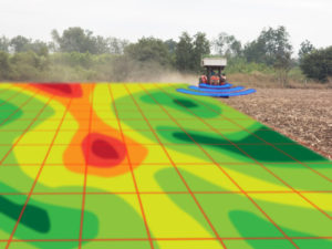
What areas benefit the most from an infield bedrock verification survey?

Summary of the HYDROGEOLOGICAL CHARACTERIZATION OF THE TOWN OF LINCOLN, KEWAUNEE COUNTY, WISCONSIN
What is top of bedrock?

Geology, Groundwater, Geophysics, and WI DNR NR 151 Runoff Management Standards

A History of Groundwater Protection Past Present and Future

References and links for agricultural professionals, farmers, engineers, geologists, geophysicists,…