Here a reader will find FAQs within numerous posts on topics relating to mapping Silurian bedrock. The information is more supportive than instrumental in how to map bedrock. The topics range from some history about the EPA, estimates of how much manure is there, who benefits from infield bedrock verification, a case history, links to interesting web sites, what is bedrock, glossary of geologic terms, and a review of WI DNR NR 151 Runoff Management Standards.
Below are short excerpts from select posts within this site, click on a subheading below to visit a specific post.
How much land is needed?
This post discusses the amount of land that is necessary to meet NR 151’s requirements. Without doubt, these are some very basic order of magnitude type of calculations. Several resources provide good estimates of how much manure farm animals produce. The rates are per pounds of farm animals. By roughly knowing how much manure an agricultural facility produces one can calculate how much land is needed, based on application rates for solid manure and liquid manure.
What areas benefit the most from an infield bedrock verification survey?
Given there is a limited amount of land, a farmer or agricultural facility needs to plan carefully how to allocate their resources, a sort of agricultural triage. Some will find the land is simply not suited for a nutrient management program. Others will see that the current standards have no restrictions that restrict applications based on the presence of Silurian bedrock. On the other hand, a fair number will likely find they may be able to reclassify their land to a less restrictive category. By all means, there are many other factors to consider; however, they are not directly related to mapping bedrock.
Summary of the HYDROGEOLOGICAL CHARACTERIZATION OF THE TOWN OF LINCOLN, KEWAUNEE COUNTY, WISCONSIN
This very informative case history is by the Wisconsin Geological and Natural History Survey Report. The program points out the pros and cons of mapping near surface bedrock. Some of the difficulties include problems with sparse and poorly spaced data, problems with locating existing data on a map, problems with presentation, and problems with identifying bedrock. As a result, it points out how geophysical methods assisted and the difficulties they ran into while performing the survey. The program included passive seismic, electrical resistivity imaging or tomography, electromagnetic terrain conductivity ( EM ), and ground penetrating radar ( GPR ).
What is top of bedrock?
As one will find out, defining what is the top of bedrock is not an exact science. It is very important to understand the subtleties because NR 151 requires infield bedrock verification. Thus, it is important to Wisconsin agricultural facilities as to what may produce desirable results. There are factors to consider. For example, currently available data like the maps from SnapPlus are defining the top of rock. At the same time, SnapPlus has a standard disclaimer, which suggests otherwise (in my opinion). Subsequently, how do we determine the top of rock? This site talks about existing geophysical methods, well logs, drilling, trenching, and other direct methods of observation.
A History of Groundwater Protection Past Present and Future
This post provides a brief history chronicling the formation of the Environmental Protection Agency, also known as the EPA, and its role in groundwater protection. It describes the environmental movement that made the general public more aware of air, water, and chemical/pesticide pollution. The formation of the EPA centralized the response to pollution prevention and clean-up and set scientifically based standards. It leads the charge to prevent and cleanup sites of groundwater contaminiation by passing the clean water act, the superfund act, regulating underground storage tank sites, and setting standards for nutrient and manure runoff.
References and links for agricultural professionals, farmers, engineers, geologists, geophysicists, and anyone else.
This post offers a wide variety of links to websites. For example, you will find websites on farm and dairy associations, manure, Wisconsin State Government, County Government, and a variety of news articles on Wisconsin DNR’s NR 151 regulations and its impact.
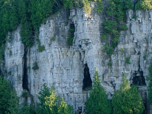
FAQs : Can groundwater dissolve dolomite? The voids seen along Lake Michigan’s cliff face in Door Co. is evidence of how groundwater flows through bedrock dissolving the dolomite.
Geology, Groundwater, Geophysics, and WI DNR NR 151 Runoff Management Standards
Indeed, NR 151 is about far more than infield bedrock verification. It covers issues with runoff for many industries (e.g. construction, fueling and maintenance areas, and transportation facilities). So the question is why are agricultural facilities part of NR 151? It has to do with nutrient management and total maximum daily loads, which are defined by the US EPA and managed by the state. This post presents sections of NR 151 as they pertain to agriculture. Specifically, sections are highlighted that relate to bedrock, fractures, groundwater, geophysics, and direct conduits. While karst is not defined or mentioned in the section for agricultural facilities, the definition of direct conduits and the concern about fractures and other paths for groundwater flow makes karst features a concern.
Glossary of definitions and terms for bedrock mapping.
To assist readers with understanding some of the terminology, there is a need for a glossary of terms. The United States Department of Agriculture ( USDA ) government agency, via the Natural Resources Conservation Service or NRCS, offers the National Soil Survey Handbook or NSSH where one will find a very large glossary. Portions of the list of 1161 or so terms are quoted here, with references, definitions, and purpose.